There are various websites revealing the weird and wonderful oddities thrown up by the Google mapping projects. Google ‘Google Map Fail’ or ‘Google Streetview Fail’ for examples, including the location of Tessa Jowell inside the Houses of Parliament, complete with directions for reaching ‘Tony Blair’ in the time of 4 hours 40 mins.  The aerial mapping project has similarly revealed amazing vast drawings in remote desert regions, viewable only from the air; jet fighters laid up in municipal car parks; and Coca Cola logos in surprising places. By chance, I found one of my own when I was looking at the topography of the Oxfordshire / Wiltshire border.
Something of interest in a field close to Ashbury?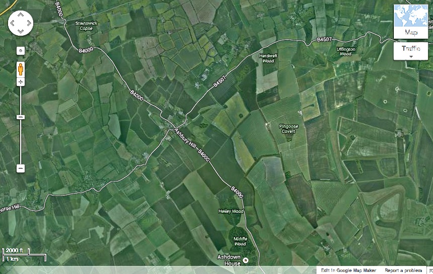
Zoom in – what on earth is that in the field near top centre?
Mmmmm. Looks familiar, but out of place…

Good grief – aliens have been at work…

…and they plainly know all about undersea creatures on Earth

It is certainly beautiful. I am always amazed at the projects that people become involved in and their imagination. I think their imagination fascinates me more than the jellyfish.
LikeLike
Agreed. A great deal of ingenuity and planning goes into these, I imagine. I’d love to watch a crop circle being made… oh, sorry, aliens do that when no one is looking! RH
LikeLike
Haha that’s fabulous! You are eagle-eyed indeed, RH, to have spotted that.
LikeLike
It’s odd what can catch the eye by complete chance… I’ve noticed strange-shaped fields and woods before, and ox-bows in rivers, but never a crop circle or equivalent. Maybe I ought to spend a week and minutely scan Google-Wilts, I thought. Mrs Harbour walked out on day 2… RH (*sallybercowjokeyface*)
LikeLike
Interesting! Thanks for another great post.
LikeLike